Other sites
|
Clairegoutte Lutheran church Little is known about the origins of Clairegoutte Church, which may date from the 12th century and is said to be built on the ruins of an ancient, pagan temple. In the north-east corner a niche suggests there used to be a statue. The west wall is very markedly in the Roman style. This church was thoroughly renovated in 1734 and a stone bell-tower was built in 1777 to replace two wooden bell-towers. The bell tower is in the middle of the wall overlooking the village and not at one of the ends of the nave as was traditional. The rectangular windows in the style of the architect Schickhardt, were inspired by those in the Lutheran church of Saint Martin’s in Montbéliard. An interior gallery of Wurtemburg-style oak columns, lines most of the building. Built in the 18th century for the congregation of Frederic-Fontaine, it led to the blocking out the rose window in the choir. During the restoration of the church undertaken in 1966-67, this rose window was reinstated. It was raised and a stained glass window by Etienne Lovy, depicting the Good Shepherd installed. The old 13th century stone altar which decorated the garden in the presbytery, was recut and reinstalled as a baptismal font. The current altar was equipped with a cross by Georges Deloraine made of Hungarian oak encrusted with enamels from Limoges. The 17th-century pulpit, inspired by the one where Martin Luther preached, was also restored according to a drawing by Cranach. Lastly, the beautiful sandstone staircase, behind metal railings, was entirely rebuilt in 1990, giving a majestic character to the church. |
 |
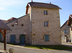 |
Clairegoutte Nail Workshop This typical building is next to a traditional barn. It is square and higher than the barn and close to a now little-used mill stream. The nail-making workshop is situated opposite the farm. The craft activities were located close to streams, but over time these hydraulic power sources were used less frequently, as from the 18th century, work became concentrated in Montbéliard. |
|
The Fountain Wash House in Belverne
|
 |
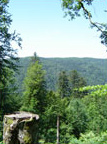  |
The Forest of Saint Antoine and the Waterfalls of the Rahin valley |
|
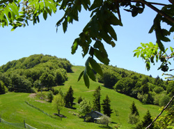
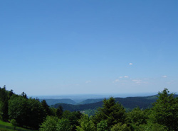
At this altitude, firs and beeches dominate; but numerous other species are also present because of the different types of relief. The reforestation of the 19th century introduced the spruce, still a major component in the forest today. These conditions favour rare natural habitats, such as peat bogs, but also moors or high altitude pastures. Between the granite rocks, we also find bilberries. In addition to very rich and important flora, the protected environment in this sector allows the development of rare and unique fauna: such as capercaillies. To protect these habitats, various procedures have been organized over the years. Today, the Franche Comté peaks Nature Reserve covers 2259 hectares and manages the environmental protection and the social aspects of this protected zone. |
|
|
The forest of Chérimont The forest of Chérimont extends over 686 hectares. It belonged to the Prince of Wurtemburg-Montbéliard and became the property of the State when the Principality of Montbéliard was incorporated into France in 1793. Numerous boundary markers still exist with the sculptured antlers of deer, the emblem of the princes of Würtemberg. Beech is present throughout the forest, sometimes mixed with sessile oak and makes up approximately 70 % of the woodland. This forest, which was managed with the aim of converting it to a regular plantation forest from 1860 on, aims essentially to produce broadleaf wood for timber and firewood, while taking into account the protection of habitats and landscapes and increasing the diversity of broad-leaved trees (sessile oak, maple, sycamore, wild cherry and sweet chestnut etc.).
|
 |
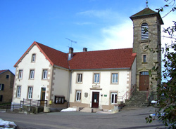 |
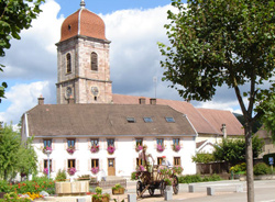
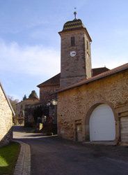
Frédéric-Fontaine's Town Hall – School - Church |
| A small vertical opening is situated over the door. Higher up, the stone clock with enamelled hands is surmounted by a large window with a full arch covered by a wooden louver shutter. The cornice is decorated with mouldings and corbels. The side wall of the church is similar to the main facade, except for the door which is replaced here by an arched window. The rear facade possesses only a clock and a louver shutter. As for the gable end of the roof of this town hall-school, the only feature on this wall is a wooden louver shutter. |
|
|
Planche des Belles Filles summer and winter resort
La Planche de Belles Filles, is also the story of a legend: the Planche-des-Belles-Filles was the scene of an atrocious massacre during the Thirty Years War. Between 1618 and 1648, a terrible conflict opposing German Protestant princes and the Catholic Imperial authority, became international with the intervention of France and their ally, Sweden. The mercenary leaders who led this war were at the head of undisciplined troops from all over the place, who were cruel and devastated the area. Alsace, the Vosges and Franche Comté suffered under the Swedes, who were the cruellest: plundering, raping, setting fires, and mass killings were common, taking place on an almost daily basis. In 1635, during the snowy winter, the Swedes under the orders of Mansfeld, a brutal war chief acting for Richelieu, went back up the Rahin valley to quarter in Plancher-les-Mines. The farmers of the Rahin and Savoureuse valleys (on the Belfort side of the mountain), ran to hide on the Saint Antoine mountain with the few possessions they had and some livestock. |
 |
| The wives and the girls who had even more to be afraid of with the Swedes, continued through the snow, up to the summit of the Ballon of Auxelles, where they thought they would be safe. But they were betrayed and the Swedes found the farmers’ refuge. The massacre lasted until dawn and they were all killed, apart from a child who managed to escape and run towards the high altitude pastures at the summit of the ‘ballon’ (The rounded mountain summits in this area are known as ‘ballons’ in French.) to alert the women. But in the snow, his tracks were easy to follow, and the soldiers were hard on his heels. The women understood the danger and knew what awaited them, horrible torture and death, so to escape their fate they rushed down the steep slopes of the Ballon and threw themselves into the black waters of the lake. Only one girl is said to have escaped drowning and lived to tell the tale. It is from this time on that the lake and the overhang above, were called "Belles Filles ". |
|
 |
The Franche Comté peaks Nature reserve
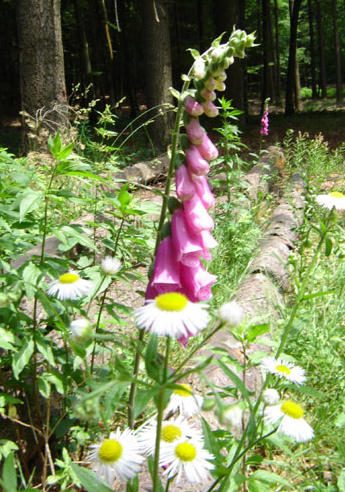
The Franche Comté peaks nature reserve includes "25 different habitats among which 18 of major importance". 95 % of the reserve is covered in forest; it is also characterized by the presence of high prairies (moors, high mountain pastures), of peat bogs, scree and cliffs. These specific habitats are home to a wealth of fauna, including "70 protected vertebrate animal species, among which 10% are of European interest ". Among them the Capercaillie, the Tengmalm Owl, the Peregrine falcon … In addition there are numerous mountain plant species (ferns, orchids, etc.). The regulations for the Franche Comté peaks nature reserve were fixed by the ministerial decree n°2002-692 of July 4th, 2002 which created the reserve and the order of the prefect D2 D2/R/2005 R n°15 of May 17th, 2005, which defines a Plan for the Organization of Park Frequentation. The sensitive period from December 15th to July 14th is always taken into account. Hiking is possible on the marked trails all year round; it is even possible to walk off these trails between 15/07 and 15/12, except for some more fragile zones (Bravouse and Rossely peat bogs). Pony trekking and mountain biking are authorized on the marked trails all year round. Skiing and hiking on snowshoes are authorized on marked trails during the winter period. |
|
Bilberries: the picking of bilberries is authorized from 15/07 to 15/12 for up to 2 kg / person / day (family consumption). The use of the comb, is tolerated in the reserve if it is used well (no lifting or breaking of the woody parts), can be also be regulated at a local level by the prefect. It is the case in the department of the Haute-Saône, the use of the comb is forbidden here (unlike Vosges and the Territoire de Belfort where there are no orders from the prefect on this subject). The collection of mushrooms for the purposes of family consumption is authorized from 15/07 to 15/12 for up to 2 kg/ person / day. Dogs are forbidden in the reserve as is flower-picking, mineral collection, photography using a hide, off-road motor vehicles, camping, fires, garbage dumping, noise pollution and the destruction of animal and plant species. Hunting, fishing and organized sports events have specific regulations. |
|
|
Alfred Schwartzentrüber's sawmill As time went by, a circular saw, a planing machine and a joiner's workshop were set up on the other bank of the canal. Bernard Michaud acquired the saw mill in 1979 and used it occasionally until the end of the ‘80s. Totally neglected since then, it got very rundown. The diesel engine is currently being restored, but because of its rare construction the task is complicated. Visits have been organized since 2005 for European Heritage Day, every second weekend of September, as well as during International Plancher-Bas walks in April and September. |
 |
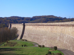 |
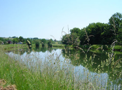
Champagney Lake Surface: 107 hectares (1,07 Km2) Maximum volume of water: 13 million m3 of water Length of the dam: 785 metres Height: 411,85 m Perimeter: approximately 7kms The dam-reservoir at Champagney was built to feed the Canal from Montbéliard to Haûte-Saône. It is the main structure on the canal. After the war of 1870-71, when Alsace and Lorraine were lost to Germany, the waterways which were of considerable economic interest at the time were no longer completely accessible (Rhine - Rhone Canal Rhine – Marne canal). It was decided that the Eastern Canal should be built to connect these two canals. It was built in record time (1875-1887), a Montbéliard-Nancy link was added that also served the coal field in Ronchamp. The Montbéliard - Haûte-Saône canal project was approved in 1882. The 85 km-long canal was to connect the Rhone canal to the Rhine (at Fesches-le-Chatel) to the Saône (at Conflandey). The canal watershed reach between Châlonvillars (Haute-Saône) and the exit of the tunnel at Chérimont to the Southeast of Ronchamp (Haute-Saône) over about 10 km. At this height (374,75 m), there is no waterway with a high enough flow rate to feed the canal all year round. Only a torrent: the Rahin, coming off the Vosges mountains is capable of bringing a certain volume of water. The solution was a reservoir that was created by blocking the higher part of the Seruillot stream valley, which could receive and hold a volume of water estimated at 11 000 000 cubic meters. A channel 3 km 500 in length and of a section which can take a 7000 litre / second flow rate feeds the dam from the water intake situated on the Rahin at Plancher-Bas. The definitive project for the dam was drawn up in 1881. It was approved by a minister on January 27th, 1882. |
|
The same year, the work began and it continued until 1905. However there were problems, in particular with the watertightness of the dam. Other major work had to be carried out which meant that the reservoir was first filled in 1938: 56 years after work began! Meanwhile, the work on the water link between Montbéliard and the Haute-Saône had been stopped, and only the section ending at the Port of Botans (close to Belfort), from the Rhône-Rhine canal, was put into service in 1932. A feeder channel from Bavilliers on the Haute-Saône canal up to the watershed reach of the Rhône-Rhine canal was built between 1937 and 1949. It currently allows water from the Dam at Champagney to feed the Rhône-Rhine canal. |
|
|
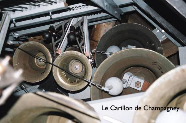
The Carillon in Champagney The wonderful instrument which almost disappeared is part of the heritage of Champagney. 1929: Creation of a carillon encouraged by a talented musician: Canon Gaillard. He lived out a dream which he had had for a very long time. Luck was on his side, because the typical Franche-Comté style bell tower was not really designed to take such an instrument but was big enough for the project. |
 |
|
1975: More bad luck for the carillon. A lightning strike meant the carillon was out of use once more to the great disappointment of all. Everyone got involved in the work, the original makers of the instrument, the Paccard company was contacted. Mister PACCARD Junior came to Champagney, happy to carry on the work which his father had begun. His analysis was clear: a return to mechanical activation was required to restore all its artistic value to the carillon and avoid any further risks from lightning strikes. The profile of the bells made in 1929 in an ‘economy series’ was relatively thin, this meant the tone could not be corrected. The bells did not have a high-quality tone. Taking this into account, 4 were kept, 9 bells from 1929 were recast in1984 and 1985, and their inscriptions were kept, 4 of them were recast in front of 50 people from Champagney on December 19th, 1984, 8 bells cast in 1985 were obtained by recasting bells from 1929 and 7 new ones completed the carillon in 1985. The task OF THE FRIENDS OF the CARILLON continued. A carillon school was created to ensure the future of the instrument. |
|
 |
The Horsetail Cube In 1989, the village of Ronchamp began the renovation of its centre, in particular its two main squares: the first in front of the Post office and the Church, the second in the Market place. These two spaces had not undergone any notable changes since the thirties and were making a poor impression on the growing numbers of visitors, who found there was not much to link the famous work of Le Corbusier and the village below. |
|
The group of artists had the idea to stack on the ground alignments of diverse materials suggesting the deep geological strata and sculptures and urban objects with lines and colours in the spirit of "Ronchamp from above ". In the centre of a complex associating progresses, squares, car parks and living spaces, the Horsetails Cube crystallizes the whole idea. Situated in the marketplace, this monument is part of the mining trails which are proposed to the visitors to Ronchamp. |
|
|
The port of Frahier and the irrigation canal The canal is not very well-known to the people of Champagney. These notes taken from topographic accounts and departmental archives will tell you a little more about it. The underground passage through the forest: |
 |
|
The underground passage at Chérimont: Six shafts spaced out at 180m intervals are used for ventilation, they are between 50 and 70m deep. The last unfinished shaft was dug to a depth of 10m. A respectable coping 3m high and of an outside diameter of 4m protects them. |
|
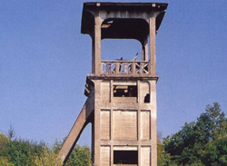 |
Saint Marie’s Mine Shaft Boring of Saint Marie’s mine shaft began on April 1st 1864, at the foot of Bourlémont hill. 359 meters deep, through sandstone and red clay, this mine shaft produced very little coal. In coal fields, ventilation is essential to fight against problems caused by: After closure in 1958, the galleries of the Saint Marie shaft were filled in. Thanks to Doctor Maulini, doctor of the mine and founder of the Mining museum, it was not destroyed. The site was fitted out and secured in 1994. Today, the Saint Marie shaft is the only visible vestige of the mining activity in Ronchamp. |
|
Altarpiece of the church of Plancher-Bas The church at Plancher-Bas dates from 1488 and is dedicated to Saint-Pancrace. (known in English as Saint-Pancras). The building was destroyed by a violent fire in 1771. The nave and the bell tower were quickly rebuilt the following year.
|
|
| Back to the main page | |